
Intermarkets' Privacy Policy
Donate to Ace of Spades HQ!
aceofspadeshq at gee mail.com
Buck:
buck.throckmorton at protonmail.com
CBD:
cbd at cutjibnewsletter.com
joe mannix:
mannix2024 at proton.me
MisHum:
petmorons at gee mail.com
J.J. Sefton:
sefton at cutjibnewsletter.com
Daily Tech News 30 July 2026
Wednesday Night ONT - July 29, 2026 [TRex]
Wednesday Cafe
Department of Education Investigates Minnesota's Use of "Trans Dolls" with Swappable Genitalia to Promote Transgenderism to Young Children
"Trans" Man Beats Mother to Death With Hammer
Coalition of Immigrant-Owned Grocery Stores Will Sue Communist Terrorist Zohran Mamdani for Using State Money to Subsidize Their Competitors
Iran Threatens Lives of First Lady and Barron Trump; Trump Says He'll Kick the Sh** Out of Them
MS NOW "National Security Reporter" Took a Luxury All-Expenses Paid Junket Paid for by Communist China's Intelligence Services, Then Wrote Articles Trashing Trump for Criticzing China
Media Can't Stop Boo-Hoo Whinin' and Cryin' That Trump Is Deporting The Democrats' Best Voters
Jon Ekdahl 2026
Jay Guevara 2025
Jim Sunk New Dawn 2025
Jewells45 2025
Bandersnatch 2024
GnuBreed 2024
Captain Hate 2023
moon_over_vermont 2023
westminsterdogshow 2023
Ann Wilson(Empire1) 2022
Dave In Texas 2022
Jesse in D.C. 2022
OregonMuse 2022
redc1c4 2021
Tami 2021
Chavez the Hugo 2020
Ibguy 2020
Rickl 2019
Joffen 2014
maildrop62 at proton dot me
Tropical Storm Isaac (tmi3rd)
Good evening, Morons and Moronettes, and greetings from the AoSHQ Weather Desk. Moron kbdabear coined the term "Geraldo Cantore", and in relation to this storm, he is sooooo right. People have been beating the drum about this (so far) garden-variety storm, and they're not helping anything. So let's get this above the fold and then we'll take it from there.
This storm is not Katrina, redux. So don't panic if you're in its path.
Thank you. More below the fold.
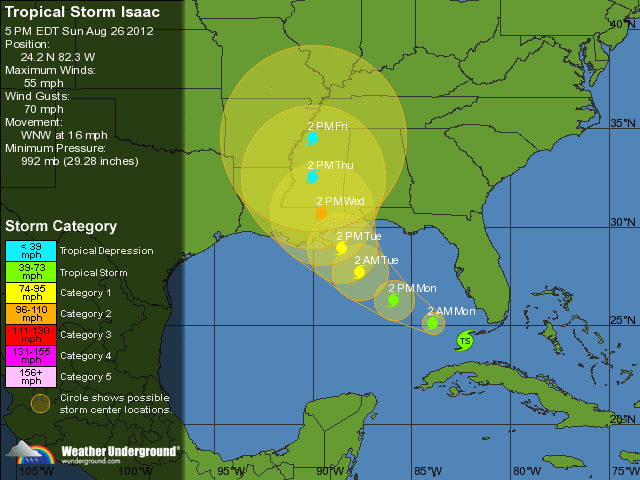
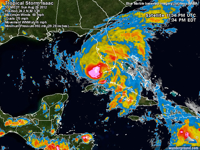
So Isaac is currently a good-looking tropical storm with winds of 65 mph. For those of you on the East Coast and in the Midwest, you've been through worse winter storms than that. The satellite pic is pretty nice-looking- what was a ragged, asymmetric storm is getting its act together, and it's definitely strengthening.
It's also hauling ass. As you notice from the above graphic, it's moving west-northwest at 16 mph. That's absolutely flying for most hurricanes. That means it won't have time to strengthen unless it abruptly slows down.
Now, the modeling can't decide where it wants to bring Isaac ashore, and there's a good 300-mile-disagreement with regards to many of them. For the moment, the forecast track above takes it in more or less right at the MS/LA line, and that seems pretty reasonable. The forecast track has shifted west over the past few days- started at Destin, FL; then Mobile, AL; then Biloxi, MS; and now New Orleans. Given how this has behaved, the Weather Desk's advisors (who actually do this stuff for a living) aren't weighing in on where they think Isaac will go specifically. As such, it's probably a good idea not to guess unless you're placing bets on its landfall.
For folks down in Florida, you can expect your usual heavy rainfall and gale-force winds for another day or two, and you'll want to be on the lookout for flooding (not like you weren't already). Hopefully, that's about as exciting as it gets for you.
Safety notes: first of all, for us Gulf Coast natives, again, this is a garden-variety tropical storm that will probably become a garden-variety hurricane. The usual precautions should already be underway, and if you're directly on the beach, it's probably a good idea to get inland a bit further. There won't be any "slosh models" (flooding models) until we have a better idea of timing, intensity, and tides.
Also, though many may already be aware of this, the ugly side of the storm is the northeast quadrant. The shear is highest there, the rain tends to be heaviest there, and you do occasionally get a tornado or two out of hurricanes that way (usually of the EF-0 variety).
Wrapping up- the public advisory notes the following:
a Hurricane Warning is in effect for...
* east of Morgan City Louisiana to Destin Florida...including metropolitan New Orleans...Lake Pontchartrain...and Lake Maurepas
a Hurricane Watch is in effect for...
* east of Destin to Indian Pass Florida
a Tropical Storm Warning is in effect for...
* the Florida Peninsula from Sebastian Inlet southward on the East
Coast and from Tarpon Springs southward on the West Coast.
* Florida Keys...including the Dry Tortugas and Florida Bay
* Lake Okeechobee
* east of Destin Florida to the Suwannee River
I don't want to downplay it to the point where nobody takes it seriously, but this is what we prepare for every year. As long as nobody does anything stupid (and someone inevitably does), this should be something less than what it's being blown up into. Again, if you're along the northern Gulf Coast, start wrapping up your preparations, and if you're in low-lying areas, have your evacuation route ready.
If you've got questions for me, find me on Twitter at my handle... we've got a fantasy draft tonight, so I won't be quite as available as I usually am.
Thanks for reading!
-tmi3rd

r hennigantx: "Happy Thursday ..."
fd: " In our local news, Sharkeya Roniece Lane was arre ..."
LinusVanPelt: "Sorry dude all you got was the name and notations, ..."
Yudhishthira's Dice: "Talarico bought and loved a Fauci doll. That alone ..."
Rev. Wishbone: ">>>Fascinating that amazingly smart people are in ..."
Hillary Clinton : " *hic* ..."
Smell the Glove : "Talarico bought and loved a Fauci doll. That alone ..."
actually inside the beltway: "And the ability to produce and deploy electronic a ..."
Hadrian the Seventh: " [i]Hadrian, what did you and HM decide about tha ..."
vmom deport deport deport: "Oh the company leadership is all dot indian Figur ..."
TecumsehTea: "Hadrian, what did you and HM decide about that off ..."
Daily Tech News 30 July 2026
Wednesday Night ONT - July 29, 2026 [TRex]
Wednesday Cafe
Department of Education Investigates Minnesota's Use of "Trans Dolls" with Swappable Genitalia to Promote Transgenderism to Young Children
"Trans" Man Beats Mother to Death With Hammer
Coalition of Immigrant-Owned Grocery Stores Will Sue Communist Terrorist Zohran Mamdani for Using State Money to Subsidize Their Competitors
Iran Threatens Lives of First Lady and Barron Trump; Trump Says He'll Kick the Sh** Out of Them
MS NOW "National Security Reporter" Took a Luxury All-Expenses Paid Junket Paid for by Communist China's Intelligence Services, Then Wrote Articles Trashing Trump for Criticzing China
Media Can't Stop Boo-Hoo Whinin' and Cryin' That Trump Is Deporting The Democrats' Best Voters
Paul Anka Haiku Contest Announcement
Integrity SAT's: Entrance Exam for Paul Anka's Band
AllahPundit's Paul Anka 45's Collection
AnkaPundit: Paul Anka Takes Over the Site for a Weekend (Continues through to Monday's postings)
George Bush Slices Don Rumsfeld Like an F*ckin' Hammer
Democratic Forays into Erotica
New Shows On Gore's DNC/MTV Network
Nicknames for Potatoes, By People Who Really Hate Potatoes
Star Wars Euphemisms for Self-Abuse
Signs You're at an Iraqi "Wedding Party"
Signs Your Clown Has Gone Bad
Signs That You, Geroge Michael, Should Probably Just Give It Up
Signs of Hip-Hop Influence on John Kerry
NYT Headlines Spinning Bush's Jobs Boom
Things People Are More Likely to Say Than "Did You Hear What Al Franken Said Yesterday?"
Signs that Paul Krugman Has Lost His Frickin' Mind
All-Time Best NBA Players, According to Senator Robert Byrd
Other Bad Things About the Jews, According to the Koran
Signs That David Letterman Just Doesn't Care Anymore
Examples of Bob Kerrey's Insufferable Racial Jackassery
Signs Andy Rooney Is Going Senile
Other Judgments Dick Clarke Made About Condi Rice Based on Her Appearance
Collective Names for Groups of People
John Kerry's Other Vietnam Super-Pets
Cool Things About the XM8 Assault Rifle
Media-Approved Facts About the Democrat Spy
Changes to Make Christianity More "Inclusive"
Secret John Kerry Senatorial Accomplishments
John Edwards Campaign Excuses
John Kerry Pick-Up Lines
Changes Liberal Senator George Michell Will Make at Disney
Torments in Dog-Hell
The Ace of Spades HQ Sex-for-Money Skankathon
A D&D Guide to the Democratic Candidates
Margaret Cho: Just Not Funny
More Margaret Cho Abuse
Margaret Cho: Still Not Funny
Iraqi Prisoner Claims He Was Raped... By Woman
Wonkette Announces "Morning Zoo" Format
John Kerry's "Plan" Causes Surrender of Moqtada al-Sadr's Militia
World Muslim Leaders Apologize for Nick Berg's Beheading
Michael Moore Goes on Lunchtime Manhattan Death-Spree
Milestone: Oliver Willis Posts 400th "Fake News Article" Referencing Britney Spears
Liberal Economists Rue a "New Decade of Greed"
Artificial Insouciance: Maureen Dowd's Word Processor Revolts Against Her Numbing Imbecility
Intelligence Officials Eye Blogs for Tips
They Done Found Us Out, Cletus: Intrepid Internet Detective Figures Out Our Master Plan
Shock: Josh Marshall Almost Mentions Sarin Discovery in Iraq
Leather-Clad Biker Freaks Terrorize Australian Town
When Clinton Was President, Torture Was Cool
What Wonkette Means When She Explains What Tina Brown Means
Wonkette's Stand-Up Act
Wankette HQ Gay-Rumors Du Jour
Here's What's Bugging Me: Goose and Slider
My Own Micah Wright Style Confession of Dishonesty
Outraged "Conservatives" React to the FMA
An On-Line Impression of Dennis Miller Having Sex with a Kodiak Bear
The Story the Rightwing Media Refuses to Report!
Our Lunch with David "Glengarry Glen Ross" Mamet
The House of Love: Paul Krugman
A Michael Moore Mystery (TM)
The Dowd-O-Matic!
Liberal Consistency and Other Myths
Kepler's Laws of Liberal Media Bias
John Kerry-- The Splunge! Candidate
"Divisive" Politics & "Attacks on Patriotism" (very long)
The Donkey ("The Raven" parody)