
Intermarkets' Privacy Policy
Donate to Ace of Spades HQ!
aceofspadeshq at gee mail.com
Buck:
buck.throckmorton at protonmail.com
CBD:
cbd at cutjibnewsletter.com
joe mannix:
mannix2024 at proton.me
MisHum:
petmorons at gee mail.com
J.J. Sefton:
sefton at cutjibnewsletter.com
Overnight Open Thread [06/01/2026]
The Wide World of Herding Cafe
Video Released of Cops Chatting Amiably with Sikh Murderer as the Victim Henry Nowak Bleeds to Death on the Ground
Another Migrant Who Can't Speak a Word of English Plows His Vehicle Into Americans, Killing a Family of Four, Another Woman, and Leaving Forty Injured
Plus: The Adulterous Nazi Communist Is Also a Cokehead
"Doctor" Jill Biden Sticks to Her Lie That She "Never, Ever" Saw Biden Showing Signs of Cognitive Decline "Before or Since" the Debate
Clinton and Obama Judges Combine to Overrule the Military's Judgment about Good Military Order, Insist That No One Can Reject Transgenders In the Military for Any Proper Logical Reasons
60 Minutes' Smelly Leftist Scott Pelley Knows He's About to be Fired, So He Stages a Tantrum-Flounce to Make It Seem Like He Was Fired in Retalliation for #FightingThePower
An Illegal Alien Previously Deported Three Times was Blocked from a New Deportation by California's Sanctuary Law.
Now He's Murdered Two Women -- and an Infant Baby
More: The Nazi Communist Stimulated by Poop Posted Lewd Photos on an App Used by Minors to Arrange Hook-Ups
The App Is Called a "Predator's Paradise" For Allowing Hook-Ups with Minors, and Platner Had An Active Account Until This Past Weekend
Jon Ekdahl 2026
Jay Guevara 2025
Jim Sunk New Dawn 2025
Jewells45 2025
Bandersnatch 2024
GnuBreed 2024
Captain Hate 2023
moon_over_vermont 2023
westminsterdogshow 2023
Ann Wilson(Empire1) 2022
Dave In Texas 2022
Jesse in D.C. 2022
OregonMuse 2022
redc1c4 2021
Tami 2021
Chavez the Hugo 2020
Ibguy 2020
Rickl 2019
Joffen 2014
maildrop62 at proton dot me
Texas MoMe 2026: 10/16/2026-10/17/2026 Corsicana,TX
Contact Ben Had for info
The Morning Rant: AI-Driven Redistricting?

Gee, has anyone noticed that federal legislative districts are in the news? Well, we have been screwing with them for the last 184 years, when The Apportionment Act of 1842 was passed. Some states were still electing at-large representatives, some states had multiple member districts, and it was a bit of a mess. Some states continued their wayward ways and there were other apportionment acts passed.
Oh...wait! Elbridge Gerry (of Gerrymander fame!) was screwing with them in 1812, and I am sure there were manipulations before then. The real issue is that there are no laws governing the creation of legislative districts that can rein in the base instincts of politicians. Partisan manipulation of districts has been found by the courts to be permissible, and that has overwhelmed the demands of "compactness," and maintaining political subdivisions like counties, cities, and neighborhoods within rational districts.
"Compactness?" That's a joke. Look at dozens of districts across America and the contortions the mapmakers went through to create, preserve, or destroy particular districts for partisan gain. Hell, the entirety of New England has zero members of the House of Representatives. That is insulting to our republican form of government, and even to our nonexistent but sound-bite-creating "democracy!"
So how can it be fixed, and what would it look like if it were?
Enter AI, which makes the creation of legislative maps a relatively easy process. It is by no means perfect, because the various systems are nowhere near intelligent enough to do what is requested. For instance, it took several iterations to explain to ChatGPT that Wyoming has only one legislative district, it is Republican, and Colorado doesn't get to snake one of theirs into Wyoming! It's actually an excellent way to see the many shortcomings of AI, and how far it needs to go. To be fair, my version of ChatGPT does not have access to the some of the data, like census blocks, and some of the more sophisticated GIS.
Here is a map that has some interesting restrictions. I began with rules that districts must emanate from the center of major cities, must respect "compactness," and city and county borders. I continued to tweak it, reminding the AI over and over that it must obey the specified rules. Some of the mistakes were marvelous! Pittsburgh was solidly Republican for a few iterations, and the Florida panhandle was Democrat. Yeah...AI is not smart.
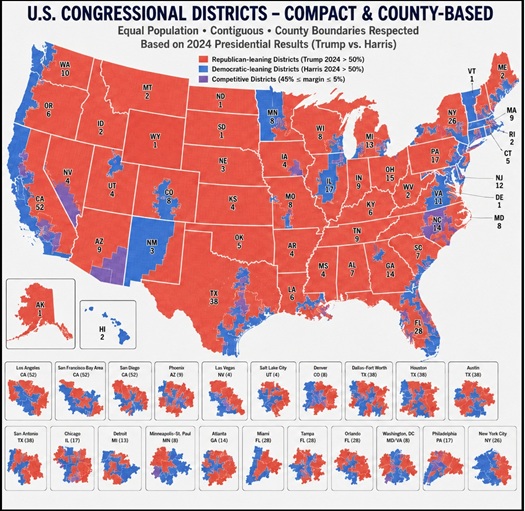
This was based on 2024 voting patterns, and is probably a bit optimistic, but it shows a solid Republican majority, even with what seems to be under-representation in the major cities. The breakdown by state is illuminating, in part because smaller states are difficult to balance politically, but the larger states are also hamstrung by their large Democrat majorities in the cities.
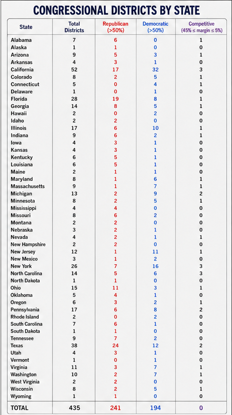
This is an intellectual exercise, and will never be enacted by any state legislature. There is simply too much at stake. But it does expose the difficulties of creating reasonable legislative districts that represent the people, rather than the entrenched interests in the various statehouses.
[Crossposted at CutJibNewsletter and X/Twitter]. If you folks who are on X/Twitter would follow us it would be much appreciated!

clarence: "Well, I drop in to see if the tech thread is up an ..."
m: "(uKTuk) ewww Perhaps this will require a bar ..."
m: "519 I'm just bolled over by the top pic. Posted ..."
Biden's Dog sniffs a whole lotta malarkey, : "I'm just bolled over by the top pic. Posted by: ..."
m: "3 I'm just bolled over by the top pic. Posted by: ..."
Skip: "Long commute today ..."
BarelyScaryMary : "My mother loved babies. She cared for babies, like ..."
Cow Demon: "493 More military-age Muslim men continue to arriv ..."
Cow Demon: "My mother loved babies. She cared for babies, like ..."
Cow Demon: "509 I say we just pull out of Europe and let them ..."
Braenyard - some Absent Friends are more equal than others _: "They aren't worth one American life. We have wast ..."
Overnight Open Thread [06/01/2026]
The Wide World of Herding Cafe
Video Released of Cops Chatting Amiably with Sikh Murderer as the Victim Henry Nowak Bleeds to Death on the Ground
Another Migrant Who Can't Speak a Word of English Plows His Vehicle Into Americans, Killing a Family of Four, Another Woman, and Leaving Forty Injured
Plus: The Adulterous Nazi Communist Is Also a Cokehead
"Doctor" Jill Biden Sticks to Her Lie That She "Never, Ever" Saw Biden Showing Signs of Cognitive Decline "Before or Since" the Debate
Clinton and Obama Judges Combine to Overrule the Military's Judgment about Good Military Order, Insist That No One Can Reject Transgenders In the Military for Any Proper Logical Reasons
60 Minutes' Smelly Leftist Scott Pelley Knows He's About to be Fired, So He Stages a Tantrum-Flounce to Make It Seem Like He Was Fired in Retalliation for #FightingThePower
An Illegal Alien Previously Deported Three Times was Blocked from a New Deportation by California's Sanctuary Law.
Now He's Murdered Two Women -- and an Infant Baby
More: The Nazi Communist Stimulated by Poop Posted Lewd Photos on an App Used by Minors to Arrange Hook-Ups
The App Is Called a "Predator's Paradise" For Allowing Hook-Ups with Minors, and Platner Had An Active Account Until This Past Weekend
Paul Anka Haiku Contest Announcement
Integrity SAT's: Entrance Exam for Paul Anka's Band
AllahPundit's Paul Anka 45's Collection
AnkaPundit: Paul Anka Takes Over the Site for a Weekend (Continues through to Monday's postings)
George Bush Slices Don Rumsfeld Like an F*ckin' Hammer
Democratic Forays into Erotica
New Shows On Gore's DNC/MTV Network
Nicknames for Potatoes, By People Who Really Hate Potatoes
Star Wars Euphemisms for Self-Abuse
Signs You're at an Iraqi "Wedding Party"
Signs Your Clown Has Gone Bad
Signs That You, Geroge Michael, Should Probably Just Give It Up
Signs of Hip-Hop Influence on John Kerry
NYT Headlines Spinning Bush's Jobs Boom
Things People Are More Likely to Say Than "Did You Hear What Al Franken Said Yesterday?"
Signs that Paul Krugman Has Lost His Frickin' Mind
All-Time Best NBA Players, According to Senator Robert Byrd
Other Bad Things About the Jews, According to the Koran
Signs That David Letterman Just Doesn't Care Anymore
Examples of Bob Kerrey's Insufferable Racial Jackassery
Signs Andy Rooney Is Going Senile
Other Judgments Dick Clarke Made About Condi Rice Based on Her Appearance
Collective Names for Groups of People
John Kerry's Other Vietnam Super-Pets
Cool Things About the XM8 Assault Rifle
Media-Approved Facts About the Democrat Spy
Changes to Make Christianity More "Inclusive"
Secret John Kerry Senatorial Accomplishments
John Edwards Campaign Excuses
John Kerry Pick-Up Lines
Changes Liberal Senator George Michell Will Make at Disney
Torments in Dog-Hell
The Ace of Spades HQ Sex-for-Money Skankathon
A D&D Guide to the Democratic Candidates
Margaret Cho: Just Not Funny
More Margaret Cho Abuse
Margaret Cho: Still Not Funny
Iraqi Prisoner Claims He Was Raped... By Woman
Wonkette Announces "Morning Zoo" Format
John Kerry's "Plan" Causes Surrender of Moqtada al-Sadr's Militia
World Muslim Leaders Apologize for Nick Berg's Beheading
Michael Moore Goes on Lunchtime Manhattan Death-Spree
Milestone: Oliver Willis Posts 400th "Fake News Article" Referencing Britney Spears
Liberal Economists Rue a "New Decade of Greed"
Artificial Insouciance: Maureen Dowd's Word Processor Revolts Against Her Numbing Imbecility
Intelligence Officials Eye Blogs for Tips
They Done Found Us Out, Cletus: Intrepid Internet Detective Figures Out Our Master Plan
Shock: Josh Marshall Almost Mentions Sarin Discovery in Iraq
Leather-Clad Biker Freaks Terrorize Australian Town
When Clinton Was President, Torture Was Cool
What Wonkette Means When She Explains What Tina Brown Means
Wonkette's Stand-Up Act
Wankette HQ Gay-Rumors Du Jour
Here's What's Bugging Me: Goose and Slider
My Own Micah Wright Style Confession of Dishonesty
Outraged "Conservatives" React to the FMA
An On-Line Impression of Dennis Miller Having Sex with a Kodiak Bear
The Story the Rightwing Media Refuses to Report!
Our Lunch with David "Glengarry Glen Ross" Mamet
The House of Love: Paul Krugman
A Michael Moore Mystery (TM)
The Dowd-O-Matic!
Liberal Consistency and Other Myths
Kepler's Laws of Liberal Media Bias
John Kerry-- The Splunge! Candidate
"Divisive" Politics & "Attacks on Patriotism" (very long)
The Donkey ("The Raven" parody)