Intermarkets' Privacy Policy
Support
Donate to Ace of Spades HQ!
Contact
Ace:aceofspadeshq at gee mail.com
Buck:
buck.throckmorton at protonmail.com
CBD:
cbd at cutjibnewsletter.com
joe mannix:
mannix2024 at proton.me
MisHum:
petmorons at gee mail.com
J.J. Sefton:
sefton at cutjibnewsletter.com
Recent Entries
Unfunny Anti-Childbirth Hag Chelsea Handler Gets Destroyed at Netflix Roast of Kevin Hart
Keir Starmer Vows to Remain in Office for Ten Years, Double Downs on Endless Illegal Immigration, Calls Immigration Reformers "Dangerous" and Warns They Are Taking the UK Down a "Dark Path"
Virginia Democrats Seethe and Scheme to Mass-Fire All Seven Supreme Court Justices to Replace Them With Compliant Communist Operatives, but Senate Leader Says It's No-Go
Be Back Soon
MORNING RANT - The War on Labor Expense: There Never Was a Truck Driver Shortage
Mid-Morning Art Thread
The Morning Report — 5/ 11/26
Daily Tech News 11 May 2026
Sunday Overnight Open Thread - May 10, 2026 [Doof]
Gun Thread: Mother's Day Edition!
Absent Friends
Captain Whitebread 2026
Jon Ekdahl 2026
Jay Guevara 2025
Jim Sunk New Dawn 2025
Jewells45 2025
Bandersnatch 2024
GnuBreed 2024
Captain Hate 2023
moon_over_vermont 2023
westminsterdogshow 2023
Ann Wilson(Empire1) 2022
Dave In Texas 2022
Jesse in D.C. 2022
OregonMuse 2022
redc1c4 2021
Tami 2021
Chavez the Hugo 2020
Ibguy 2020
Rickl 2019
Joffen 2014
AoSHQ Writers Group
A site for members of the Horde to post their stories seeking beta readers, editing help, brainstorming, and story ideas. Also to share links to potential publishing outlets, writing help sites, and videos posting tips to get published.
Contact OrangeEnt for info:
maildrop62 at proton dot me
maildrop62 at proton dot me
Cutting The Cord And Email Security
Moron Meet-Ups
Texas MoMe 2026: 10/16/2026-10/17/2026 Corsicana,TX
Contact Ben Had for info
« The Morning Report 10/5/16 [J.J. Sefton] |
Main
| Politico Founder Jim Van Der Hei: I've Always Defended the Media Against Bias Charges, But This Year, They've Proven Themselves to Be Hyperpartisan Embarrassments »
Hurricane Matthew-

October 05, 2016
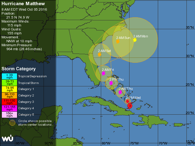
Hurricane Matthew- Tuesday NightWednesday Morning (tmi3rd)
This was scheduled for last night...so at tmi3rd's request I updated the map to the newest version. He also points out that preparations to evacuate need to be finished today if south of NC. [CBD]
Good evening from the AoSHQ Weather Desk. I'm tmi3rd, and let's not screw around.
If you are anywhere on the east coast of Florida, it is time to leave. You're going to get at least sideswiped, and that means you're going to get at least tropical storm force winds and Category 4 storm surge, to say nothing of a ton of rain.
If you're on the coast in Georgia, South Carolina, or North Carolina, you need to be completing preparations to leave and be prepared to go in the next 24 to 48 hours.
More below the fold...

A hurricane watch in effect for essentially the east coast of Florida south of St. Augustine, and a tropical storm watch is in effect for the southernmost portion of the Florida peninsula.
It's going to slow its motion going forward as it interacts with the Bahamas, but at this point, it looks like the conditions are favorable for it to maintain intensity as it heads north.
Worrying about the specifics of the path at this point is pointless until it completely clears Cuba, but I want to emphasize to the folks from Virginia northward that you need to keep a very close eye on this. It's going to turn east at some point, but it's anyone's guess when that's going to happen.
In the short term- for the southeastern Atlantic coast, prepare for very heavy rain, at least tropical storm-force winds, and major hurricane storm surge. I'll have more as this develops, but stay safe and take this one seriously.
If you need to reach me, find me on Twitter.
Recent Comments
Mark1971:
"Just saw this at The Volokh Conspiracy
Elected ..."
XTC: "22 Once you've seen Norm's roast of Bob Saget, the ..."
BlackOrchid (j+aD2): "this was funny probably would have been funnier ..."
Case: "This Starwar guy seems like a a real winner. After ..."
TheJamesMadison, discovering British horror with Hammer Films: "22 But to be fair Cloris Leachman killed that nig ..."
Ben Had: "Is this a palate cleanser or time killer thread? ..."
gKWVE: "BOGO PALESTINE! Posted by: Mark Andrew Edwards, B ..."
Mark Andrew Edwards, Buy ammo [/b] [/i]: "Now I wanna go watch old Norm MacDonald jokes... ..."
Eromero: "The child is a demon, grotesque, even poisonous. ..."
four seasons: " Pete Davidson is a shitbag. ..."
...: "Once you've seen Norm's roast of Bob Saget, there' ..."
rhomboid: "Never heard of either person, but that's increasin ..."
Recent Entries
Unfunny Anti-Childbirth Hag Chelsea Handler Gets Destroyed at Netflix Roast of Kevin Hart
Keir Starmer Vows to Remain in Office for Ten Years, Double Downs on Endless Illegal Immigration, Calls Immigration Reformers "Dangerous" and Warns They Are Taking the UK Down a "Dark Path"
Virginia Democrats Seethe and Scheme to Mass-Fire All Seven Supreme Court Justices to Replace Them With Compliant Communist Operatives, but Senate Leader Says It's No-Go
Be Back Soon
MORNING RANT - The War on Labor Expense: There Never Was a Truck Driver Shortage
Mid-Morning Art Thread
The Morning Report — 5/ 11/26
Daily Tech News 11 May 2026
Sunday Overnight Open Thread - May 10, 2026 [Doof]
Gun Thread: Mother's Day Edition!
Keir Starmer Vows to Remain in Office for Ten Years, Double Downs on Endless Illegal Immigration, Calls Immigration Reformers "Dangerous" and Warns They Are Taking the UK Down a "Dark Path"
Virginia Democrats Seethe and Scheme to Mass-Fire All Seven Supreme Court Justices to Replace Them With Compliant Communist Operatives, but Senate Leader Says It's No-Go
Be Back Soon
MORNING RANT - The War on Labor Expense: There Never Was a Truck Driver Shortage
Mid-Morning Art Thread
The Morning Report — 5/ 11/26
Daily Tech News 11 May 2026
Sunday Overnight Open Thread - May 10, 2026 [Doof]
Gun Thread: Mother's Day Edition!
Search
Polls! Polls! Polls!
Frequently Asked Questions
The (Almost) Complete Paul Anka Integrity Kick
Primary Document: The Audio
Paul Anka Haiku Contest Announcement
Integrity SAT's: Entrance Exam for Paul Anka's Band
AllahPundit's Paul Anka 45's Collection
AnkaPundit: Paul Anka Takes Over the Site for a Weekend (Continues through to Monday's postings)
George Bush Slices Don Rumsfeld Like an F*ckin' Hammer
Paul Anka Haiku Contest Announcement
Integrity SAT's: Entrance Exam for Paul Anka's Band
AllahPundit's Paul Anka 45's Collection
AnkaPundit: Paul Anka Takes Over the Site for a Weekend (Continues through to Monday's postings)
George Bush Slices Don Rumsfeld Like an F*ckin' Hammer
Top Top Tens
Democratic Forays into Erotica
New Shows On Gore's DNC/MTV Network
Nicknames for Potatoes, By People Who Really Hate Potatoes
Star Wars Euphemisms for Self-Abuse
Signs You're at an Iraqi "Wedding Party"
Signs Your Clown Has Gone Bad
Signs That You, Geroge Michael, Should Probably Just Give It Up
Signs of Hip-Hop Influence on John Kerry
NYT Headlines Spinning Bush's Jobs Boom
Things People Are More Likely to Say Than "Did You Hear What Al Franken Said Yesterday?"
Signs that Paul Krugman Has Lost His Frickin' Mind
All-Time Best NBA Players, According to Senator Robert Byrd
Other Bad Things About the Jews, According to the Koran
Signs That David Letterman Just Doesn't Care Anymore
Examples of Bob Kerrey's Insufferable Racial Jackassery
Signs Andy Rooney Is Going Senile
Other Judgments Dick Clarke Made About Condi Rice Based on Her Appearance
Collective Names for Groups of People
John Kerry's Other Vietnam Super-Pets
Cool Things About the XM8 Assault Rifle
Media-Approved Facts About the Democrat Spy
Changes to Make Christianity More "Inclusive"
Secret John Kerry Senatorial Accomplishments
John Edwards Campaign Excuses
John Kerry Pick-Up Lines
Changes Liberal Senator George Michell Will Make at Disney
Torments in Dog-Hell
Greatest Hitjobs
The Ace of Spades HQ Sex-for-Money Skankathon
A D&D Guide to the Democratic Candidates
Margaret Cho: Just Not Funny
More Margaret Cho Abuse
Margaret Cho: Still Not Funny
Iraqi Prisoner Claims He Was Raped... By Woman
Wonkette Announces "Morning Zoo" Format
John Kerry's "Plan" Causes Surrender of Moqtada al-Sadr's Militia
World Muslim Leaders Apologize for Nick Berg's Beheading
Michael Moore Goes on Lunchtime Manhattan Death-Spree
Milestone: Oliver Willis Posts 400th "Fake News Article" Referencing Britney Spears
Liberal Economists Rue a "New Decade of Greed"
Artificial Insouciance: Maureen Dowd's Word Processor Revolts Against Her Numbing Imbecility
Intelligence Officials Eye Blogs for Tips
They Done Found Us Out, Cletus: Intrepid Internet Detective Figures Out Our Master Plan
Shock: Josh Marshall Almost Mentions Sarin Discovery in Iraq
Leather-Clad Biker Freaks Terrorize Australian Town
When Clinton Was President, Torture Was Cool
What Wonkette Means When She Explains What Tina Brown Means
Wonkette's Stand-Up Act
Wankette HQ Gay-Rumors Du Jour
Here's What's Bugging Me: Goose and Slider
My Own Micah Wright Style Confession of Dishonesty
Outraged "Conservatives" React to the FMA
An On-Line Impression of Dennis Miller Having Sex with a Kodiak Bear
The Story the Rightwing Media Refuses to Report!
Our Lunch with David "Glengarry Glen Ross" Mamet
The House of Love: Paul Krugman
A Michael Moore Mystery (TM)
The Dowd-O-Matic!
Liberal Consistency and Other Myths
Kepler's Laws of Liberal Media Bias
John Kerry-- The Splunge! Candidate
"Divisive" Politics & "Attacks on Patriotism" (very long)
The Donkey ("The Raven" parody)

