
Intermarkets' Privacy Policy
Donate to Ace of Spades HQ!
aceofspadeshq at gee mail.com
Buck:
buck.throckmorton at protonmail.com
CBD:
cbd at cutjibnewsletter.com
joe mannix:
mannix2024 at proton.me
MisHum:
petmorons at gee mail.com
J.J. Sefton:
sefton at cutjibnewsletter.com
Daily Tech News 18 July 2026
Look At Me I'm ONT
Friday Cafe
The Same Media That Pushed Hillary's Fake Opposition Research About Russia Collusion For Six Years Can't Believe Trump Is Alleging Election Irregularities
Scott Bessent: A Deranged Leftist Attempted to Assassinate Me Shortly After I Became Secretary of the Treasury
The New Republic: Don't You Understand You're Forcing Us Lefties to Murder You?
Trump: We Recovered Documents From the CIA About Their Scheme to Hide All Intelligence from Me That Could Help Me in My 2020 Re-Election Campaign
Maine Democrats' Debate to Replace Graham Platner Sparks Question, "Say, Why Did We Get Rid of Graham Platner?"
As US Forces Knock Out Iranian Power Plants, the IRGC Tells Iranians to be Like the UK and France and Turn Off the AC and Die In the Summer Heat
Trump: There Is Evidence of a Massive Chinese Effort to Compromise America's Voting Rolls -- But the Deep State Covered It Up
Jon Ekdahl 2026
Jay Guevara 2025
Jim Sunk New Dawn 2025
Jewells45 2025
Bandersnatch 2024
GnuBreed 2024
Captain Hate 2023
moon_over_vermont 2023
westminsterdogshow 2023
Ann Wilson(Empire1) 2022
Dave In Texas 2022
Jesse in D.C. 2022
OregonMuse 2022
redc1c4 2021
Tami 2021
Chavez the Hugo 2020
Ibguy 2020
Rickl 2019
Joffen 2014
maildrop62 at proton dot me
Tropical Storm Erika 8/28/15 (tmi3rd)
Good evening from the AoSHQ Weather Desk, Morons and Moronettes. I'm tmi3rd, and I'll be continuing my nightly eye on Erika until the storm dissipates. Some interesting things have happened over the last 24 hours with Erika, and I think we'll enjoy the media disappointment over it.
More below the fold...
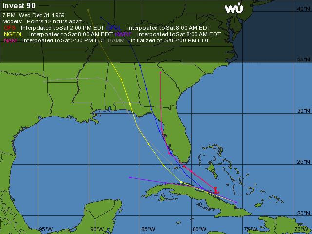
So you'll notice the track has shifted back to the west, which comes as something of a surprise to me, but this is largely in response to the shape of the high pressure area that it's moving around.
The other thing is, with its path taking it straight over Hispaniola and Cuba, it doesn't look like it's going to reach the continental United States as a hurricane. In point of fact, it's entirely possible it won't even make it ashore as a tropical storm, due to a combination of terrain and speed.
This will, of course, totally WRECK the planned news cycle for the weekend, which requires an editorial by Nelson Muntz:
Thanks, Nelson.
Now- if you're living in Florida anywhere from Miami to at least Apalachicola, you do need to stay alert for flooding. I will remind you that there have already been fatalities on the island of Dominica (where I have friends in medical school, at Ross University). Dominica saw a foot of rain, and flooding is what causes the most fatalities in tropical cyclones.
You're still going to get *some* storm surge. How much and where depend on the storm's exact track and speed, and we won't have a better feel for that until we see what it does over the next couple of days.
So, to recap:
Good news: Erika is increasingly unlikely to hit land as anything more than a middling tropical storm, and that will in turn wreck the weekend news cycle.
Bad news: you're still looking at a major-league rain event that has already killed some people, and if you're in a low-lying area in pretty much all of Florida, you need to keep your eyes on it.
That's what I've got for you tonight- more later! As ever, you can find me on Twitter if you need me.
Thanks for reading!
-tmi3rd

"Perfessor" Squirrel: ""I'm reminded of “A Man, A Plan, A Canal, ..."
m: "150 "I'm reminded of “A Man, A Plan, A Ca ..."
fd: ""I'm reminded of “A Man, A Plan, A Canal, ..."
m: "142 I am reminded of the lyrics of a song Berserke ..."
fd: "At the end of that contract there were 4 left. ..."
NaCly Dog: "Good morning! Let's smile & be happy & strike ..."
fd: "Zenith Z-100s? At one time I had a contract to ser ..."
m: "138 The morning news is full of scare stuff today, ..."
IllTemperedCur: " Remember when the Army used the Enable office su ..."
Common Tater: "It would seem to me, given the myriad agencies and ..."
fd: "I am reminded of the lyrics of a song Berserker po ..."
Daily Tech News 18 July 2026
Look At Me I'm ONT
Friday Cafe
The Same Media That Pushed Hillary's Fake Opposition Research About Russia Collusion For Six Years Can't Believe Trump Is Alleging Election Irregularities
Scott Bessent: A Deranged Leftist Attempted to Assassinate Me Shortly After I Became Secretary of the Treasury
The New Republic: Don't You Understand You're Forcing Us Lefties to Murder You?
Trump: We Recovered Documents From the CIA About Their Scheme to Hide All Intelligence from Me That Could Help Me in My 2020 Re-Election Campaign
Maine Democrats' Debate to Replace Graham Platner Sparks Question, "Say, Why Did We Get Rid of Graham Platner?"
As US Forces Knock Out Iranian Power Plants, the IRGC Tells Iranians to be Like the UK and France and Turn Off the AC and Die In the Summer Heat
Trump: There Is Evidence of a Massive Chinese Effort to Compromise America's Voting Rolls -- But the Deep State Covered It Up
Paul Anka Haiku Contest Announcement
Integrity SAT's: Entrance Exam for Paul Anka's Band
AllahPundit's Paul Anka 45's Collection
AnkaPundit: Paul Anka Takes Over the Site for a Weekend (Continues through to Monday's postings)
George Bush Slices Don Rumsfeld Like an F*ckin' Hammer
Democratic Forays into Erotica
New Shows On Gore's DNC/MTV Network
Nicknames for Potatoes, By People Who Really Hate Potatoes
Star Wars Euphemisms for Self-Abuse
Signs You're at an Iraqi "Wedding Party"
Signs Your Clown Has Gone Bad
Signs That You, Geroge Michael, Should Probably Just Give It Up
Signs of Hip-Hop Influence on John Kerry
NYT Headlines Spinning Bush's Jobs Boom
Things People Are More Likely to Say Than "Did You Hear What Al Franken Said Yesterday?"
Signs that Paul Krugman Has Lost His Frickin' Mind
All-Time Best NBA Players, According to Senator Robert Byrd
Other Bad Things About the Jews, According to the Koran
Signs That David Letterman Just Doesn't Care Anymore
Examples of Bob Kerrey's Insufferable Racial Jackassery
Signs Andy Rooney Is Going Senile
Other Judgments Dick Clarke Made About Condi Rice Based on Her Appearance
Collective Names for Groups of People
John Kerry's Other Vietnam Super-Pets
Cool Things About the XM8 Assault Rifle
Media-Approved Facts About the Democrat Spy
Changes to Make Christianity More "Inclusive"
Secret John Kerry Senatorial Accomplishments
John Edwards Campaign Excuses
John Kerry Pick-Up Lines
Changes Liberal Senator George Michell Will Make at Disney
Torments in Dog-Hell
The Ace of Spades HQ Sex-for-Money Skankathon
A D&D Guide to the Democratic Candidates
Margaret Cho: Just Not Funny
More Margaret Cho Abuse
Margaret Cho: Still Not Funny
Iraqi Prisoner Claims He Was Raped... By Woman
Wonkette Announces "Morning Zoo" Format
John Kerry's "Plan" Causes Surrender of Moqtada al-Sadr's Militia
World Muslim Leaders Apologize for Nick Berg's Beheading
Michael Moore Goes on Lunchtime Manhattan Death-Spree
Milestone: Oliver Willis Posts 400th "Fake News Article" Referencing Britney Spears
Liberal Economists Rue a "New Decade of Greed"
Artificial Insouciance: Maureen Dowd's Word Processor Revolts Against Her Numbing Imbecility
Intelligence Officials Eye Blogs for Tips
They Done Found Us Out, Cletus: Intrepid Internet Detective Figures Out Our Master Plan
Shock: Josh Marshall Almost Mentions Sarin Discovery in Iraq
Leather-Clad Biker Freaks Terrorize Australian Town
When Clinton Was President, Torture Was Cool
What Wonkette Means When She Explains What Tina Brown Means
Wonkette's Stand-Up Act
Wankette HQ Gay-Rumors Du Jour
Here's What's Bugging Me: Goose and Slider
My Own Micah Wright Style Confession of Dishonesty
Outraged "Conservatives" React to the FMA
An On-Line Impression of Dennis Miller Having Sex with a Kodiak Bear
The Story the Rightwing Media Refuses to Report!
Our Lunch with David "Glengarry Glen Ross" Mamet
The House of Love: Paul Krugman
A Michael Moore Mystery (TM)
The Dowd-O-Matic!
Liberal Consistency and Other Myths
Kepler's Laws of Liberal Media Bias
John Kerry-- The Splunge! Candidate
"Divisive" Politics & "Attacks on Patriotism" (very long)
The Donkey ("The Raven" parody)