
Intermarkets' Privacy Policy
Donate to Ace of Spades HQ!
aceofspadeshq at gee mail.com
Buck:
buck.throckmorton at protonmail.com
CBD:
cbd at cutjibnewsletter.com
joe mannix:
mannix2024 at proton.me
MisHum:
petmorons at gee mail.com
J.J. Sefton:
sefton at cutjibnewsletter.com
Thursday Cafe
Quick Hits
House Passes "Stop Insider Trading" Bill to Forbid Congressmen from Trading Individual Stocks (Using Insider Information);
Noted Lifelong Inside-Trader Nancy Pelosi Votes Against It
Amazing: Female USA "Sports" Columnist and Woke Karen Argues That Caitlin Clark Should Accept Being Fouled by Black Lesbians Because If She Complains She's Putting Black LGBTs in Danger
CIA Report: Air Power Alone Can't Win Wars
Ethiopian Migrant Culturally Enriches Three American Citizens In, Get This, Minnesota
One of JD Vance's Secret Service Agents Is Under Investigation for Leaking "Sensitive" Information
Jim Jordan Makes a Criminal Referral to the DOJ For Jack Smith's Perjury; Melania Presses Sanctions Against Democrat Media Party Hatchet Man Michael Wolff
The Morning Rant
Jon Ekdahl 2026
Jay Guevara 2025
Jim Sunk New Dawn 2025
Jewells45 2025
Bandersnatch 2024
GnuBreed 2024
Captain Hate 2023
moon_over_vermont 2023
westminsterdogshow 2023
Ann Wilson(Empire1) 2022
Dave In Texas 2022
Jesse in D.C. 2022
OregonMuse 2022
redc1c4 2021
Tami 2021
Chavez the Hugo 2020
Ibguy 2020
Rickl 2019
Joffen 2014
maildrop62 at proton dot me
Tropical Storm Isaac, noon EDT (tmi3rd)
This post has been promoted by Drew M. in light of the impending landfall of Tropical Storm Isaac.
Good morning from the AoSHQ weather desk. We'll be updating these with time stamps because information will be updated every three hours at the NHC and NWS. The next one is due at 2 EDT. The next AoSHQ advisory on this will happen as the High Command decides it's necessary.
Important stuff: Tropical Storm Isaac is anticipated to make landfall (the center of circulation will hit land) sometime on Tuesday, probably somewhere between the mouth of the Mississippi River and Morgan City, LA. Maximum sustained winds are currently 65 mph, and its movement is northwest at 13 mph.
More beneath the fold...
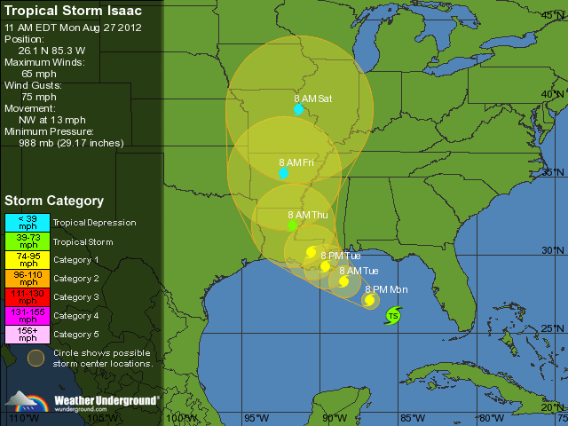
Two things that jump out about this: one, the storm didn't strengthen much overnight, which was something of a surprise. As of the morning advisory, the maximum sustained winds were 55 mph, and it's strengthened some today.
If it stays on its current course, it'll hit Barataria Bay, which is about ten or fifteen miles due south of the house I grew up in. Of course, when it hits land, it'll wobble a bit, so we'll see where it actually goes ashore.
The current thinking in terms of intensity is that it will top out at around 90 mph maximum sustained winds, which makes it a solid Category 1 hurricane. Storm surge effects will be highest on the northeast quadrant of the storm, which means if you're anywhere from Terrebonne Parish, LA east to the AL/FL border, you're looking at 6-12 feet higher water than normal. South central Louisiana is looking at 3-6 feet, as is the Florida panhandle.
Rainfall estimates, as are customary with any landfalling hurricane, are between 12-15 inches anywhere along the eastern side of the storm. It may not be that much, but be prepared for that possibility. Tornadoes are also a possibility anywhere along the northern Gulf Coast (usually EF-0 in intensity).
This kind of storm is almost an annual occurrence along the northern Gulf Coast, so take your usual precautions. If you're on the beach, you do need to finish your preparations swiftly. If you're heading inland, go now, please.
As ever, the greatest loss of life with any hurricane is usually inland flooding- just stay away from high water and don't do anything dumb.
Watches and warnings:
a Hurricane Warning is in effect for...
* east of Morgan City Louisiana to Destin Florida...including metropolitan New Orleans...Lake Pontchartrain...and Lake Maurepas
a Hurricane Watch is in effect for...
* Intracoastal City to Morgan City Louisiana
a Tropical Storm Warning is in effect for...
* east of Destin Florida to the Aucilla river
* Intracoastal City to Morgan City Louisiana
a tropical storm watch is in effect for...
* east of Sabine Pass to west of Intracoastal City Louisiana
If you need me, find me on Twitter at my handle. What we're hoping for, by the way, is that Isaac will make its way up into Oklahoma and Kansas and beat up on our drought.
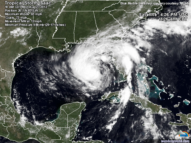
Thanks for reading! I leave you with the current satellite shot of Isaac...
-tmi3rd

ChristyBlinkyTheGreat: "259 I find it hard to believe that U.S. Sen. Mark ..."
...: "Posted by: NemoMeImpuneLacessit at July 23, 2026 0 ..."
Braenyard - some Absent Friends are more equal than others _: "SPCX bottomed out, for a moment, at ~111 today. I ..."
mindful webworker - man v beast: "The guy beating the ostrich reminds me of the fell ..."
Alberta Oil Peon: "Evening, Ace, and Cafe patrons! Almost closing tim ..."
NemoMeImpuneLacessit[/i][/b][/u][/s]: "No, I am pointing out what no rights means. I am n ..."
t-bird: "[i]Oh... they are opening the spillways on the dam ..."
Braenyard - some Absent Friends are more equal than others _: "Ever smell a dog? Ever smell a wet dog? ..."
ChristyBlinkyTheGreat: "The ostrich attack will appear later in my dreams ..."
Romeo13: "123 Storm Bertha having an effect . . . Posted ..."
PRS: "[i]iThey must have some rights as human beings, ma ..."
Thursday Cafe
Quick Hits
House Passes "Stop Insider Trading" Bill to Forbid Congressmen from Trading Individual Stocks (Using Insider Information);
Noted Lifelong Inside-Trader Nancy Pelosi Votes Against It
Amazing: Female USA "Sports" Columnist and Woke Karen Argues That Caitlin Clark Should Accept Being Fouled by Black Lesbians Because If She Complains She's Putting Black LGBTs in Danger
CIA Report: Air Power Alone Can't Win Wars
Ethiopian Migrant Culturally Enriches Three American Citizens In, Get This, Minnesota
One of JD Vance's Secret Service Agents Is Under Investigation for Leaking "Sensitive" Information
Jim Jordan Makes a Criminal Referral to the DOJ For Jack Smith's Perjury; Melania Presses Sanctions Against Democrat Media Party Hatchet Man Michael Wolff
The Morning Rant
Paul Anka Haiku Contest Announcement
Integrity SAT's: Entrance Exam for Paul Anka's Band
AllahPundit's Paul Anka 45's Collection
AnkaPundit: Paul Anka Takes Over the Site for a Weekend (Continues through to Monday's postings)
George Bush Slices Don Rumsfeld Like an F*ckin' Hammer
Democratic Forays into Erotica
New Shows On Gore's DNC/MTV Network
Nicknames for Potatoes, By People Who Really Hate Potatoes
Star Wars Euphemisms for Self-Abuse
Signs You're at an Iraqi "Wedding Party"
Signs Your Clown Has Gone Bad
Signs That You, Geroge Michael, Should Probably Just Give It Up
Signs of Hip-Hop Influence on John Kerry
NYT Headlines Spinning Bush's Jobs Boom
Things People Are More Likely to Say Than "Did You Hear What Al Franken Said Yesterday?"
Signs that Paul Krugman Has Lost His Frickin' Mind
All-Time Best NBA Players, According to Senator Robert Byrd
Other Bad Things About the Jews, According to the Koran
Signs That David Letterman Just Doesn't Care Anymore
Examples of Bob Kerrey's Insufferable Racial Jackassery
Signs Andy Rooney Is Going Senile
Other Judgments Dick Clarke Made About Condi Rice Based on Her Appearance
Collective Names for Groups of People
John Kerry's Other Vietnam Super-Pets
Cool Things About the XM8 Assault Rifle
Media-Approved Facts About the Democrat Spy
Changes to Make Christianity More "Inclusive"
Secret John Kerry Senatorial Accomplishments
John Edwards Campaign Excuses
John Kerry Pick-Up Lines
Changes Liberal Senator George Michell Will Make at Disney
Torments in Dog-Hell
The Ace of Spades HQ Sex-for-Money Skankathon
A D&D Guide to the Democratic Candidates
Margaret Cho: Just Not Funny
More Margaret Cho Abuse
Margaret Cho: Still Not Funny
Iraqi Prisoner Claims He Was Raped... By Woman
Wonkette Announces "Morning Zoo" Format
John Kerry's "Plan" Causes Surrender of Moqtada al-Sadr's Militia
World Muslim Leaders Apologize for Nick Berg's Beheading
Michael Moore Goes on Lunchtime Manhattan Death-Spree
Milestone: Oliver Willis Posts 400th "Fake News Article" Referencing Britney Spears
Liberal Economists Rue a "New Decade of Greed"
Artificial Insouciance: Maureen Dowd's Word Processor Revolts Against Her Numbing Imbecility
Intelligence Officials Eye Blogs for Tips
They Done Found Us Out, Cletus: Intrepid Internet Detective Figures Out Our Master Plan
Shock: Josh Marshall Almost Mentions Sarin Discovery in Iraq
Leather-Clad Biker Freaks Terrorize Australian Town
When Clinton Was President, Torture Was Cool
What Wonkette Means When She Explains What Tina Brown Means
Wonkette's Stand-Up Act
Wankette HQ Gay-Rumors Du Jour
Here's What's Bugging Me: Goose and Slider
My Own Micah Wright Style Confession of Dishonesty
Outraged "Conservatives" React to the FMA
An On-Line Impression of Dennis Miller Having Sex with a Kodiak Bear
The Story the Rightwing Media Refuses to Report!
Our Lunch with David "Glengarry Glen Ross" Mamet
The House of Love: Paul Krugman
A Michael Moore Mystery (TM)
The Dowd-O-Matic!
Liberal Consistency and Other Myths
Kepler's Laws of Liberal Media Bias
John Kerry-- The Splunge! Candidate
"Divisive" Politics & "Attacks on Patriotism" (very long)
The Donkey ("The Raven" parody)