
Intermarkets' Privacy Policy
Donate to Ace of Spades HQ!
aceofspadeshq at gee mail.com
Buck:
buck.throckmorton at protonmail.com
CBD:
cbd at cutjibnewsletter.com
joe mannix:
mannix2024 at proton.me
MisHum:
petmorons at gee mail.com
J.J. Sefton:
sefton at cutjibnewsletter.com
Deep State Mafia Boss Anthony "Little Bones" Fauci Pleads the Fifth
Wednesday Morning Rant
Mid-Morning Art Thread
The Morning Report — 7/ 29 /26
Daily Tech News 29 July 2026
Tuesday Overnight Open Thread - July 28, 2026 [Doof]
Sick Day Cafe
House Committee Issues Subpoenas to Far-Left Chinese Asset Megadonor Neville Roy Singham
Families of 9/11 Victims Want Terrorist-Loving Communist Zohran Mamdani Banned from 25th Anniversary Remembrance
Jon Ekdahl 2026
Jay Guevara 2025
Jim Sunk New Dawn 2025
Jewells45 2025
Bandersnatch 2024
GnuBreed 2024
Captain Hate 2023
moon_over_vermont 2023
westminsterdogshow 2023
Ann Wilson(Empire1) 2022
Dave In Texas 2022
Jesse in D.C. 2022
OregonMuse 2022
redc1c4 2021
Tami 2021
Chavez the Hugo 2020
Ibguy 2020
Rickl 2019
Joffen 2014
maildrop62 at proton dot me
Hurricane Hermine (tmi3rd)
Good morning, Morons and Moronettes. The AoSHQ Weather Desk comes to you this morning with a somewhat late update on Hermine, which looks like it's going to actually make it to hurricane status before making landfall in west central Florida.
Even though it's not going to be a big wind event, as many of you know, there's still going to be a ton of rain, and forward speed is pretty much the key thing to how much rain you're going to get.
Details beneath the fold...
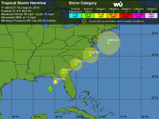
As of the 11 AM EDT advisory, Hermine is a strong tropical storm with maximum sustained winds of 65 mph and gusts to 75 mph, and is projected to become a hurricane later today. It is currently about 170 miles SSW of Apalachicola, FL, or 220 miles west of Tampa. Motion is currently north-northeast at 14 mph, and lowest measured barometric pressure is 991 millibars.
A hurricane warning is in effect from Suwanee River to Mexico Beach, FL. A tropical storm warning is in effect from Anclote River to Suwanee River, west of Mexico beach to the Walton/Bay County line, and Marineland to Surf City.
A hurricane watch is in effect from Anclote River to Suwanee River, and west of Mexico Beach to the Walton/Bay County line. A tropical storm watch is in effect for north of Surf City to Oregon Inlet, including Pamlico Sound.
The National Hurricane Center likes the following numbers for storm surge heights:
The water could reach the following heights above ground if the
peak surge occurs at the time of high tide...
Destin to Indian Pass...1 to 3 feet
Indian Pass to Ochlockonee River...4 to 7 feet
Ochlockonee River to Keaton Beach...5 to 8 feet
Keaton Beach to Chassahowitzka...4 to 7 feet
Chassahowitzka to Aripeka...2 to 4 feet
Aripeka to Bonita Beach...including Tampa Bay...1 to 3 feet
Florida-Georgia line to Cape Fear...1 to 3 feet
The other key thing will be rainfall and the odd tornado. Here's what the NHC likes in that regard:
Rainfall: Hermine is expected to produce storm total rainfall
accumulations of 5 to 10 inches over portions of northwest Florida
and southern Georgia through Friday, with possible isolated maximum
amounts of 20 inches. On Friday and Saturday, Hermine is expected
to produce totals of 4 to 8 inches with isolated maximum amounts of
10 inches possible across portions of eastern Georgia, South
Carolina, and eastern North Carolina through Saturday. These rains
may cause life-threatening flash flooding.
Tornadoes: a few tornadoes are possible this afternoon into Friday
morning over North Florida and southeast Georgia. The tornado risk
will continue across the eastern Carolinas from Friday morning into
Friday night.
So here's the tl;dr version: if you're along the west coast of Florida, this is a VERY asymmetric storm that is going to suck up and push a lot of water ashore, particularly east of Apalachicola. If you're on the northeast side of the storm, you're going to get the most water and the most shear. The northeast side of the storm is where you typically get the odd EF-1 tornado, so I'm advising you to stay aware if you're anywhere north of Tampa to about Apalachicola.
Do I really need to tell you to stay away from the beach during this? Nah, didn't think so.
Now, moving forward- it depends on where the center of circulation goes. If it pops back out over water, it could start trying to spin back up and regain some strength. By the end of the weekend, it's going to start interacting with a cold front, and that will alter its course.
So that means that if you're anywhere from the Outer Banks in NC all the way up to coastal NY, NJ, and MA, you may be staring at some very high water and some tropical weather before this thing becomes extratropical and does all kinds of unusual stuff.
Stay informed all along the East Coast, and expect this storm to slow down the more it interacts with land. It'll keep moving, but the more that it slows down, the more likely you are to get the ugly (and potentially catastrophic) rain. Stay away from flood waters, and you'll get an impromptu day off.
I'm knee-deep in med school stuff, but if you have questions, hit me up on Twitter, and I'll get back to you as soon as I can.
Stay safe, and thanks for reading!
-tmi3rd

Romeo13: "55 Has anyone suggested the illegals be put in cha ..."
whig: "Not to be obstreperous, but over the last two year ..."
Pete Buttigieg: "[i] Lotta loose shit around here lately. Post ..."
Dr. Fausti - I WAS The Science: "64 They're getting paid to leave. They'll likely c ..."
TheJamesMadison, discovering British horror with Hammer Films: "Remember, Biden let in millions by just not enforc ..."
LinusVanPelt: "Stealers Wheel… damn, thought they were name ..."
LizLem: ">>> you make life terrible for them, they'll leave ..."
People's Hippo Voice: "The howling we've heard from the left so far is no ..."
Guy who always says nothing: " ..."
Bonecrusher: " It's old. You should be contemplating mine. Pos ..."
TheJamesMadison, discovering British horror with Hammer Films: "Remember, Biden let in millions by just not enforc ..."
Deep State Mafia Boss Anthony "Little Bones" Fauci Pleads the Fifth
Wednesday Morning Rant
Mid-Morning Art Thread
The Morning Report — 7/ 29 /26
Daily Tech News 29 July 2026
Tuesday Overnight Open Thread - July 28, 2026 [Doof]
Sick Day Cafe
House Committee Issues Subpoenas to Far-Left Chinese Asset Megadonor Neville Roy Singham
Families of 9/11 Victims Want Terrorist-Loving Communist Zohran Mamdani Banned from 25th Anniversary Remembrance
Paul Anka Haiku Contest Announcement
Integrity SAT's: Entrance Exam for Paul Anka's Band
AllahPundit's Paul Anka 45's Collection
AnkaPundit: Paul Anka Takes Over the Site for a Weekend (Continues through to Monday's postings)
George Bush Slices Don Rumsfeld Like an F*ckin' Hammer
Democratic Forays into Erotica
New Shows On Gore's DNC/MTV Network
Nicknames for Potatoes, By People Who Really Hate Potatoes
Star Wars Euphemisms for Self-Abuse
Signs You're at an Iraqi "Wedding Party"
Signs Your Clown Has Gone Bad
Signs That You, Geroge Michael, Should Probably Just Give It Up
Signs of Hip-Hop Influence on John Kerry
NYT Headlines Spinning Bush's Jobs Boom
Things People Are More Likely to Say Than "Did You Hear What Al Franken Said Yesterday?"
Signs that Paul Krugman Has Lost His Frickin' Mind
All-Time Best NBA Players, According to Senator Robert Byrd
Other Bad Things About the Jews, According to the Koran
Signs That David Letterman Just Doesn't Care Anymore
Examples of Bob Kerrey's Insufferable Racial Jackassery
Signs Andy Rooney Is Going Senile
Other Judgments Dick Clarke Made About Condi Rice Based on Her Appearance
Collective Names for Groups of People
John Kerry's Other Vietnam Super-Pets
Cool Things About the XM8 Assault Rifle
Media-Approved Facts About the Democrat Spy
Changes to Make Christianity More "Inclusive"
Secret John Kerry Senatorial Accomplishments
John Edwards Campaign Excuses
John Kerry Pick-Up Lines
Changes Liberal Senator George Michell Will Make at Disney
Torments in Dog-Hell
The Ace of Spades HQ Sex-for-Money Skankathon
A D&D Guide to the Democratic Candidates
Margaret Cho: Just Not Funny
More Margaret Cho Abuse
Margaret Cho: Still Not Funny
Iraqi Prisoner Claims He Was Raped... By Woman
Wonkette Announces "Morning Zoo" Format
John Kerry's "Plan" Causes Surrender of Moqtada al-Sadr's Militia
World Muslim Leaders Apologize for Nick Berg's Beheading
Michael Moore Goes on Lunchtime Manhattan Death-Spree
Milestone: Oliver Willis Posts 400th "Fake News Article" Referencing Britney Spears
Liberal Economists Rue a "New Decade of Greed"
Artificial Insouciance: Maureen Dowd's Word Processor Revolts Against Her Numbing Imbecility
Intelligence Officials Eye Blogs for Tips
They Done Found Us Out, Cletus: Intrepid Internet Detective Figures Out Our Master Plan
Shock: Josh Marshall Almost Mentions Sarin Discovery in Iraq
Leather-Clad Biker Freaks Terrorize Australian Town
When Clinton Was President, Torture Was Cool
What Wonkette Means When She Explains What Tina Brown Means
Wonkette's Stand-Up Act
Wankette HQ Gay-Rumors Du Jour
Here's What's Bugging Me: Goose and Slider
My Own Micah Wright Style Confession of Dishonesty
Outraged "Conservatives" React to the FMA
An On-Line Impression of Dennis Miller Having Sex with a Kodiak Bear
The Story the Rightwing Media Refuses to Report!
Our Lunch with David "Glengarry Glen Ross" Mamet
The House of Love: Paul Krugman
A Michael Moore Mystery (TM)
The Dowd-O-Matic!
Liberal Consistency and Other Myths
Kepler's Laws of Liberal Media Bias
John Kerry-- The Splunge! Candidate
"Divisive" Politics & "Attacks on Patriotism" (very long)
The Donkey ("The Raven" parody)